
Background
Douglas Shire Council is undertaking the Port Douglas and Craiglie Flood Study to build a clearer picture of how water moves through our catchments and where flooding affects people, property and roads.
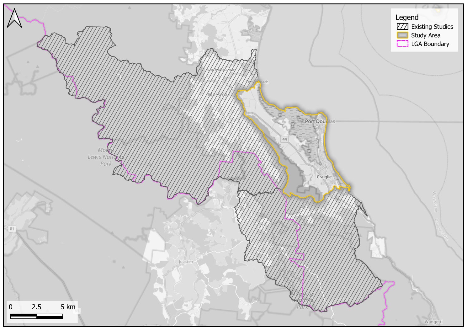
The study covers approximately 51 square kilometres, extending from the Mowbray River in the south to Cooya Beach in the north, and takes in Port Douglas and Craiglie.
It will look at flooding from a range of sources — intense rainfall, creek and river flooding, overland flow, storm tide, and the way these interact with the local drainage network.
The outputs will be used to inform future land use planning, disaster management and infrastructure investment decisions.
The study is being delivered by JB Pacific on behalf of Council and is jointly funded by the Australian and Queensland Governments under the North Queensland Resilience Program
Have Your Say
Local knowledge is one of the most valuable sources of flood information available to us. Records of what actually happened on the ground — where water went, how deep it got, which roads cut — help the project team understand flood behaviour in places where recorded data is limited.
We would like to hear from residents, business owners, property managers and visitors who experienced flooding in Port Douglas, Craiglie or the surrounding area.
We are particularly interested in three recent events:
- Tropical Cyclone Jasper — December 2023
- North Queensland rainfall and flooding — December 2025 to February 2026, with Douglas most affected over 29 to 31 December 2025
- Tropical Low 29U — the early and mid March 2026 flooding
- Any other significant flood event that affected the area
Information you provide will be considered alongside the technical investigations. It helps the project team understand local conditions and identify areas of concern.
Get Involved
There are several ways to participate:
Complete the Community Survey
The questionnaire takes around 10 minutes. You can tell us where flooding occurred, what you observed, how deep the water was, and whether it entered a building. You can also upload photographs and video
Come and talk to us
There will be two opportunities to speak with the project team in person.
Drop-in session — Wednesday 14 October 2026, 4:00pm to 6:00pm
Port Douglas Community Hall, 13–29 Mowbray Street, Port Douglas.
An informal session early in the study. Members of the project team will be on hand to hear about your experience of flooding in the area, look at photographs, and mark up locations on maps. No booking needed — come and go as it suits you.
Draft findings session — early-mid 2027
Once the draft study is complete, the project team will present the findings, explain what the mapping shows and answer questions. Details will be published on this page closer to the date.
Ask a question
Questions about the study or the consultation process can be sent to enquiries@douglas.qld.gov.au with Port Douglas and Craiglie Flood Study in the subject line.
Additional Information
What is a flood study
A flood study uses computer models of rainfall, river flows and tides to estimate how deeply and how widely water spreads across the landscape during floods of different sizes. It produces flood mapping and technical information that Council uses for planning, emergency management and infrastructure decisions.
A flood study does not, on its own, change planning controls or building requirements. Any change of that kind follows a separate process with its own consultation.
What has already happened?
Council holds a number of earlier flood investigations relevant to the area, including the Mowbray River Flood Study, the Mossman River Flood Study, Shire-wide flood mapping, and coastal hazard and storm tide work completed under the Resilient Coast program.
Council also operates rainfall gauges at Craiglie and the Port Douglas wastewater treatment plant, which have recorded each of the recent events listed above.
This study builds on that earlier work. It uses newer topographic survey data, current national rainfall guidance, and information gathered since the 2023, 2025 and 2026 flood events to produce a more detailed and up-to-date picture of flood behaviour across Port Douglas and Craiglie.
What is happening now?
The study commenced in August 2026. Over the coming months the project team will be:
- Reviewing existing flood studies, models, survey data and flood records
- Visiting the study area to inspect waterways, drainage and known problem locations
- Collecting community flood information through the questionnaire on this page
- Building and testing computer models of rainfall, river flow, storm tide and local drainage
- Preparing flood mapping for a range of flood sizes, including allowance for climate change
- Identifying locations where flooding causes problems, and indicative opportunities to improve flood resilience
The technical work will be independently peer reviewed at set points through the study.
Updates
Project updates will be published here as the study progresses
Privacy
Privacy Statement – Douglas Shire Council
Responses will not be publicly displayed. Personal information will be handled in accordance with Council’s privacy obligations and used only for the purposes of the Flood Study.