Types of natural disaster events, which may affect the Douglas region, includes:
Cyclone
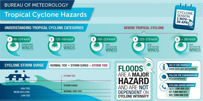
A tropical cyclone is a massive collection of whirling wind and dense cloud mass, spiralling clockwise around a central eye of exceptional low pressure. The severity of a tropical cyclone is described in terms of categories ranging from 1 (weakest) to 5 (strongest), which is related to the maximum mean wind speed.
With winds reaching speeds in excess of 200km/h, cyclones can be extremely dangerous. On average annually the Australian region experiences ten (10) cyclones. The Bureau of Meteorology keeps the public informed by issuing cyclone watches and warnings, which are available on their website.
An evacuation order for a cyclone is only issued if lives may be at risk from a storm tide surge. In the Douglas region a wind-threat does not trigger evacuation.
Things to do once a cyclone warning is issued and cyclone impact is imminent:
- Turn off power, water or gas if advised by the Douglas Local Disaster Management Group or Ergon Energy.
- Turn off outdoor LPG tanks to reduce the risk of fire if tanks are damaged or dislodged.
- Unplug small appliances, which may be affected by power surges as the cyclone approaches.
- Close all interior doors. Secure and brace external doors.
- Store drinking water in clean bathtubs, sinks, plastic bottles, cooking pots and any other safe storage containers.
- Turn off major appliances if the power is lost. Power surges may occur when electricity is restored, which can cause damage to your appliances if left on.
- Retrieve your emergency kit and ensure this is nearby at all times.
The Maritime Safety Queensland website has contingency plans to ensure stronger resilience from the maritime community. Timely awareness and adequate preparation will reduce the impact of such events. The extreme weather event contingency plan for Port Douglas sets out the particular arrangements for this region.
To learn more about past cyclones in the Shire visit Douglas Shire Historical Society Web pages:
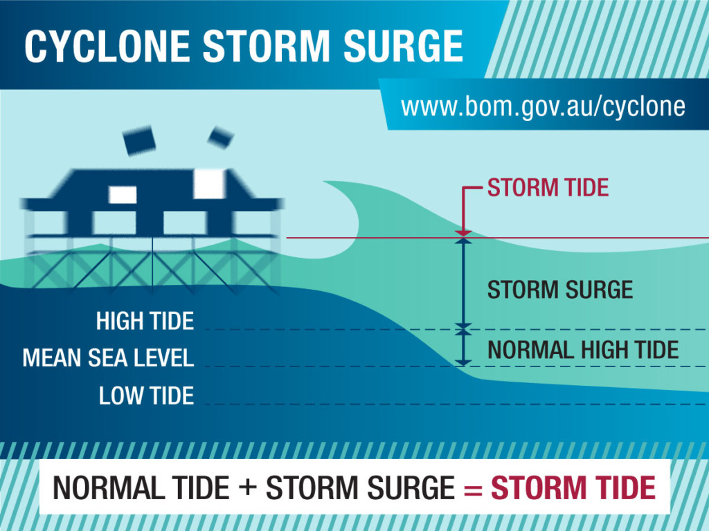
Storm Surge
Evacuation advice during cyclones in the Douglas region is based on storm surge, not wind, so it is critical to know whether you live in a storm tide surge zone.
Storm surge is a rise in the ocean level associated with cyclones. It is caused by high winds pushing on the ocean’s surface and lower than normal air pressure from the storm. As a cyclone reaches the coast, huge winds may whip up the sea and push the dome of water over low-lying coastal areas. In other words the sea may reach much further inland than it does during high tide.
If a storm surge coincides with a high tide the sea can travel even further inland, up to several kilometres.
The height of the surge is strongly influenced by geographic factors such as the shape of the seabed and coastline, the intensity and angle of approach of the cyclone to the shore and prevailing currents. The Bureau of Meteorology gives an advance warning of likely levels if a storm surge is expected, as part of its tropical cyclone advice and warning system.
There are two ways to find out if you are in a storm tide surge zone.
- Meter/power box: check the inside of your meter/power box cover for a storm surge sticker in red, orange or yellow.
- Maps: maps are available from Council’s Disaster Dashboard.
o Select ‘Storm Tide Layer’ to check the location of your property to see if you are located in one of the three Storm Tide Evacuation Zones (Red, Orange and Yellow). If your residence is located in a coloured evacuation zone, your property may be inundated in a storm tide event.
o If your property is located outside of these zones, or you are not required to evacuate, your home is often the safest place for you.
o The height of the predicted storm tide during the disaster event will determine which zones will be affected.
Flood
Our traditional wet season, which runs from November to March each year increases the risk of flooding. Flooding in general is caused by heavy rain from a cyclone or rain depression crossing the coastline. This can sometimes result in local flooding to streets, yards and in extreme events, homes.
Flooding is sometimes confused with the storm tide surge that can accompany cyclones. Although a storm tide surge can contribute to flooding, flooding can also happen as part of a cyclone without a storm tide or during a severe storm or at times of heavy rain. You may live in a storm tide surge zone, but not a flood-prone area and vice versa.
What will happen?
The Bureau of Meteorology will issue a flood watch or similar advice of possible flooding, if flood-producing rain is expected in the near future. General weather forecasts may also refer to flood–producing rain.
- A flood warning is issued when flooding is occurring or expected to occur in a particular area. When flash flooding is expected, a severe weather warning is issued.
- There will be warnings for locations likely to be affected through broadcast media, council’s websites or directly within communities by street announcements and door knocking. The emergency alert system or SEWS (State Emergency Warning System) may also be used.
- Drains, creeks or rivers which have had little or no water flow in previous months may fill rapidly with fast-flowing water, which can spread to houses and streets. The height of the water may not have been seen in the same location before.
- You may not be able to get in or out of the house or street if it is affected by flooding.
What should you do:
- Check the Disaster Dashboard for the latest information on severe weather, road closures, utility outages and evacuation routes.
- Check the information on the Bureau of Meteorology and local emergency services websites and listen for flooding information.
- Consider your local flood history.
- Do not camp in dry riverbeds as they can become flooded without warning.
- Avoid building on floodplains unless you elevate and reinforce your home.
- If your area is flood prone, consider alternatives to carpet on ground levels, such as removable floor rugs, and tiled floors and walls.
- Raise your electrical panel to a high position above flood level.
- Install check-valves in sewer traps to prevent floodwater from backing up into the drains of your house. This will prevent raw sewage from contaminating your house.
- Construct floodwalls to stop floodwater entering your home. You will need to check with Council Engineering Staff to confirm the regulations pertaining to the construction of floodwalls and levees in your area. You may not be allowed to build a floodwall in your area.
- Seal walls in basements, or those regularly exposed to flooding, with waterproofing compounds to prevent seepage through cracks.
- Have a builder add a waterproof veneer to exterior walls of your house.
- Keep a supply of sandbags, and sand to fill them with, available to sandbag doors to prevent water from entering your house.
- Unplug electrical equipment such as TVs and computers to avoid damage caused by power surges. Move household items to a higher place (e.g. on a bed or table or upstairs). This is especially important for electrical items, chemicals and perishable food, which can be all be wrapped in plastic bags, then stored in a higher place.
- Keep refrigerator and freezer doors closed so food will stay cool without power for several hours.
- Sandbag areas at risk from flooding where possible. This includes drains inside the house to help prevent sewage overflows.
- Boil tap water in case of contamination.
- If you are in area affected by flooding, are unable to move to a higher storey and/or feel unsafe, follow your household emergency plan and move to your pre-arranged location. Take your household emergency kit.
- Never drive, walk, swim or play in floodwaters. Hazards could exist below the surface which you can’t see, regardless of how well you know the area. Water could be contaminated.
In the event of a combination of heavy rain, strong winds and high tides, low-lying areas need to take extra precaution. This means moving items to higher ground where possible. Avoid parking your car on the street, as saltwater can cause permanent damage.
Bushfire
Every year, bushfires put the lives and properties of Queenslanders at risk. You do not have to live in the bush to be threatened by bushfire, just close enough to be affected by burning material, embers and smoke. They may be started through arson (deliberately lit), carelessness (e.g. discarded cigarettes, sparks from machinery or unattended fires), as the result of an accident or very rarely, as the result of a controlled/prescribed burn. If you light a fire, on purpose or accidentally, you are responsible for controlling it.
The bushfire season normally commences in North Queensland in July and progresses through to southern areas of the state as Spring approaches. These time-frames can vary significantly from year to year, depending on the fuel loads, long-term climate and short-term weather conditions in each area.
Residents are likely to be at a heightened risk of bushfire if:
- Your local area has a bushfire history.
- Your property is located within a few kilometres of bushland.
- You have trees and shrubs within 20 metres of your house.
- Your home is built on a slope.
Visit Queensland Fire Department (QFD) for current bushfire warnings and updates.
What will happen?
- If a prescribed burn is going to happen near your area, you will be told directly ahead of time (e.g. via letter, property visit).
- If fire danger levels are rising in your area, information will be broadcast on all usual media and websites such as the Bureau of Meteorology, Rural Fire Service Queensland and Douglas Shire Council website.
- Fires can move extremely fast – faster than you can run. They can also be unpredictable, for instance changing direction. You may find yourself suddenly in danger. Heat, wind, smoke and burning material blowing around may make it difficult to see, hear or breathe.
- If lives or property are threatened, you’ll receive Advice, Watch and Act or Emergency warning messages.
o An advice message tells you a fire has started and provide general information to keep you updated.
o A watch and act message represents a higher level of threat such as conditions are changing, a fire is approaching, lives may be threatened.
o An emergency warning is the highest level message advising of impending danger and you may hear the State Emergency Warning Signal (SEWS) first. With any fire warning, follow the instructions immediately.
What should I do?
- Keep an eye on the Rural Fire Service website (see contact information at the back of this brochure) when hot, dry conditions exist.
- Keep grass cut and vegetation clear of the property.
- Don’t dump garden rubbish in neighbouring reserves or bush areas.
- Move flammable items away from the house, e.g. woodpiles, boxes, hanging baskets, garden furniture.
- Keep access ways to the property clear for fire trucks.
- When warnings are given, act immediately on the instructions provided. Do not wait. Leave when advised, even if it feels safe where you are at the time. Take your household emergency kit with you. Go in the direction advised for your location.
After the fire front has passed:
- Wait until the all-clear has been given by local emergency services before leaving your safe area and returning home.
- Consider using a face mask or similar (e.g. hanky, flannel).
- Check around the property for live electricity, leaking gas, sewage leaks, hot embers, overhanging trees or branches or structural damage.
- If unsure about the safety of the property, seek advice from local emergency services. Do not take any risks.
- If you are stranded, hurt or need other help, contact emergency services.
Tsunami
Despite the presence of the Great Barrier Reef, the Douglas region can still be affected by a tsunami. Although the reef may reduce the impact of a tsunami, the scale of impact depends on what caused the tsunami, how far away the event is and where it is in relation to the Douglas region.
The effects of tsunamis originating in locations from Chile to Tonga have been recorded in Queensland since 1868. Although we do not live in a high risk area, a tsunami could also be triggered on the edge of the Great Barrier Reef. We may have only a few hours’ warning. The Tsunami Guide for Queensland 2019 provides advice on what to do in the event of a tsunami. If a tsunami warning is issued, quickly move inland and uphill.
What is a tsunami?
A tsunami is a series of waves generated by a sudden upward movement of the ocean floor due to earthquakes. Tsunamis can also be generated by undersea landslides, volcanic eruptions, and meteorite impacts. A tsunami can travel great distances, sometimes across entire oceans, at up to 950 km/h in the open sea. It can range from a few centimetres in height offshore to many metres high once the wave slows down and shoals in shallow water.
What will happen?
Tsunamis can happen any time of year. Warning information will be issued by local emergency authorities on the advice of the Bureau of Meteorology.
- If a tsunami threat is likely, information will be broadcast on all available public media such as radio, TV, websites and social media.
- It may also be provided by emergency services in areas likely to be affected, e.g. through loud hailers or door knocking.
- You may receive emergency alerts through mobile and landline phones and hear the SEWS (Standard Emergency Warning Signal).
- If you are at the beach or can see the ocean, you may notice changes such as the water withdrawing, or suddenly becoming shallow, or unusual or unexpected waves approaching.
- A tsunami may not be one large wave approaching the coast. It can occur as a series of seemingly quite low but very powerful waves. The force of the water may be so strong it can carry vehicles, boats, bridges and buildings with it.
What should I do?
- Move quickly from low lying areas to higher ground – in many situations this is just a few streets away and it will be easiest to walk.
- If you are at home and need to drive to leave, take your household emergency kit. Otherwise put emergency supplies such as a battery-operated radio and torch, medications, water, snacks and cash in a bag you can walk with.
- Do not stay to watch the tsunami!
- Head for your nearest area of higher ground. You can use the Douglas storm tide surge maps for guidance on reaching higher ground.
- Get out of the water and away from the coast.
- Follow local instructions and take immediate action, no matter how small the tsunami may sound.
- Stay where you are if your location is on high ground.
After a tsunami
- Keep listening and be alert for instructions from local emergency authorities.
- Stay in your high ground location until advised it is safe to leave. More waves are likely to follow the first and it may take time for this to happen.
- Keep out of flooded areas even if you know them well, as hazards below the water may not be apparent. Floodwaters may also be contaminated by sewage and other pollutants.
- Follow the advice provided by local emergency authorities. Call for help if you need it.
Earthquake
Earthquakes are recognised as the most devastating and unpredictable natural disaster known to human civilisation. They strike without warning at any place, at any time and can be of any size.
Although we do not have records of being severely affected by earthquakes, they are still a significant potential hazard for the Douglas region with many occurring around the area since records began. The neighbouring Tablelands and Undara areas have a long volcanic history. The Queensland State Earthquake Risk Assessment 2019 provides a comprehensive overview of earthquake risk in Queensland.
In any urban or rural area, where significant development has taken place and/or is planned for the future (such as critical facilities, infrastructure, and local development), an increasing concern is that of potential earthquake damage.
What will happen?
- Sometimes preceded by stillness, dogs barking, birds flying in flocks.
- Sometimes sounds such as rolling or rumbling may be heard.
- Movement of the earth – this could be a jolt or series of jolts of varying intensities and/or a rolling sensation.
- Inside a building items may fall from the ceiling, walls or out of cupboards, the water in toilets may slosh around, walls may crack if the shock is severe.
What should I do?
If you are indoors:
- Take cover – get under a sturdy table, bed or other piece of furniture or doorway. Hold on until the shaking stops. Otherwise, cover your face and head with your arms and crouch in an inside corner.
- Stay away from glass, windows, outside doors and walls, and anything that could fall.
- Stay inside until the shaking stops. There may be aftershocks.
- Do not use lifts.
- The electricity may go out, or sprinkler systems or fire alarms may turn on.
- Follow any instructions from emergency services.
If you are outside:
- Stay there.
- Move away from buildings, streetlights and utility wires.
- Once in the open, stay there until the shaking stops. The greatest danger exists directly outside buildings, at exits and alongside exterior walls.
- Follow any instructions from emergency services.
If you are in a moving vehicle:
- Stop as quickly as safety allows and stay in the vehicle. Avoid stopping near or under buildings, trees, overpasses, and utility wires.
- Proceed cautiously once the earthquake has stopped. Avoid roads, bridges, or ramps that might have been damaged.
- Follow any instructions from emergency services
If you are trapped:
- Do not light a match or use a lighter
- Keep as still as possible
- Cover your mouth with a handkerchief or clothing.
- Tap on a pipe or wall or call out so rescuers can locate you.
- Call 112 if your mobile phone is with you and working.
Landslide
Landslides are typically associated with heavy rainfall. Landslides can grow in volume with the addition of water, sand, mud, boulders, trees and other materials.
While landslides are not overly common in North Queensland, the largest recorded event in the region is the 1951 Ellis Beach debris flows, which buried 10k of the Captain Cook Highway. Many smaller landslides have occurred around the region since recording began in the late 1870s.

Landslip at Ponzo Rd
Council and State Government agencies undertake projects to secure the slopes to a degree of safety. Mitigation works have been carried out to protect homes from any further landslides.
What causes landslides?
Earthquakes or volcanic activity can cause landslides, but in Queensland, landslides are generally caused by heavy rain. The rain saturates the soil on a hillside—often where there has been human activity (e.g. construction where trees and plants have been removed), past the point where any remaining vegetation can support the soil’s weight against the force of gravity. The top saturated layer of soil then slips down the hill—taking whatever is on the land with it.
Movement of landslide material can vary from abrupt collapses to slow, gradual slides and at rates ranging from almost undetectable to extremely rapid. Sudden, rapid events are the most dangerous because of lack of warning and the speed at which material can travel as well, as the force of its impact.
What will happen?
You may notice changes in the yard or house such as:
- Leaning trees, slumping earth, movement in fences or trees, cracks in paths.
- Outside walls start to pull away from the building, new cracks appear in plaster, tile, brick or foundations, doors or windows stick for the first time.
- You may hear a rumbling sound, which increase as the landslip, nears. A trickle of falling mud or debris may precede a larger slip.
- Emergency services may have little or no warning of a landslide.
What should I do?
- Be aware of the area you live in – is it close to a hillslope, cliffs or steep rocky area? Is there a history of landslides?
- If there has been a period of heavy rain, you may be at risk of a landslide. Make sure your household emergency plan includes this hazard.
- If it is safe to do so, leave the area and go quickly to your agreed safer place. Advise neighbours and emergency services of the slip threat.
- If you cannot leave, move to a second storey if there is one. Otherwise curl into a tight ball and protect your head.
- Follow any instructions from emergency services.
After a landslip
- Be alert for emergency information or instructions.
- Stay away from the slip area – there may be danger of additional slips.
- Watch for flooding, which may occur after a landslide, or debris flow.
- Check for injured and trapped people near the slip, without entering the slip area.
- Look for and report broken utility lines, damaged roads etc.
- Seek help from emergency authorities if needed.
Pandemic
Queensland Health is responsible for responding to major public health incidents in the State, including pandemic influenza. In the event of an influenza pandemic in humans, Queensland Health leads and coordinates government and community partners’ efforts to protect public health.
Pandemic influenza is a worldwide outbreak of disease that can occur when a new strain of influenza, to which people are not immune, emerges and spreads. Unlike many other disasters or public health emergencies, pandemic influenza is generally not a short or localised disruption. Pandemic influenza is generally widespread and can come in waves that may last for months or years.
Visit the Queensland Government’s Pandemic Influenza site. This site provides information for the general public, health professionals and industry on how pandemic influenza could affect them in the future and the best way to prepare.