Overview
Ferry Replacement
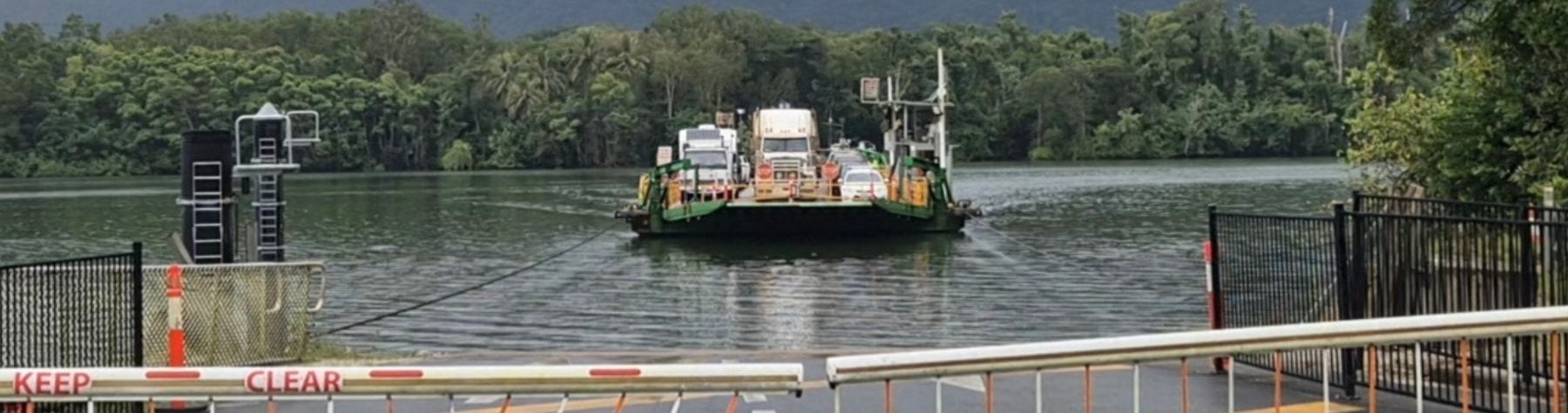
In August 2022, Council resolved to replace the existing ferry with a new, larger four-lane ferry capable of carrying more vehicles each trip. The aim is to significantly reduce wait times, improve service for residents and businesses, and provide a better tourism experience.
The ferry tender process closed on 9 April 2025. In August 2025, Council approved the recommendation to award the design, construction, and operation contract. The ferry will be built by Birdon in Port Macquarie and towed to the Daintree River in 2027. Delivery is scheduled by December 2027, with commissioning coordinated alongside the new ramp works.
Landside Infrastructure Upgrades
To go along with the new ferry, Douglas Shire Council is upgrading the approach roads and ramps on both sides of the Daintree River. These works will complement the new vessel by improving traffic flow, safety, and efficiency for all ferry users.
The upgrades will:
-
Provide additional lanes and improved queuing areas
-
Create a dedicated priority lane for local residents and cardholders
-
Improve access for tour operators and boat ramp users
-
Include new dual-loading ramps to support the four-lane ferry
Construction is planned to start after the 2026 wet season, with the new infrastructure completed in time for the ferry’s arrival at the end of 2027.
Updates
Updates on both the landside infrastructure and ferry replacement projects will continue to be shared through:
-
- Council’s website and project pages
- Media releases
- Council newsletters and the Daintree Ferry Reference Group
Public Information Session Recordings – 20 November 2025
Douglas Shire Council Project Overview
Durack Civil (Landside Infrastructure)
Birdon Pty Ltd (Ferry Replacement and Operation)
Questions (see FAQ section below for full list of questions)
Media Releases and Community Updates
- October 2024 – New Daintree River Ferry to Reduce Waiting Times with Larger Vessel
- October 2023 – Search For New Ferry Supplier/ Operator Underway
- August 2022 – Council Endorses Daintree Ferry Replacement Project
- August 2022 – Daintree Ferry Crossing Solution – click here
- June 2022 – Daintree Ferry Northern Ramp Replacement
- September 2021 – Daintree River Ferry Probity Report – click here
- May 2021 – Daintree River Ferry Service Contract – click here
- May 2021 – Daintree Ferry Purchase – click here
- November 2020 – Compass Research Report – Bridge/Ferry Survey – click here
- November 2020 – Bridge Or Ferry Submissions – click here
- August 2020 – Daintree River Crossing Options Assessment Report – click here
Council Meeting Reports
Photo’s & Concept Drawings
Concept Design Gallery: Use the arrow below to change image
")


Concept Plans
- Approved Designs (will be uploaded when available)
Frequently Asked Questions
What is this project about?
Council is upgrading the roads and ferry ramps on both sides of the Daintree River to prepare for a new, higher-capacity ferry. These works will reduce wait times, improve traffic flow, and support local residents, services, tourism, and school travel.
Why did Council choose a ferry over a bridge?
Extensive community engagement and traffic modelling were carried out across several stages. Of the 3,409 survey responses, 66% preferred an improved ferry service while 33% preferred a bridge. The outcome showed that a larger, dual-loading ferry with landside upgrades was the most practical and widely supported option.
When will construction begin?
Landside works will start after the 2026 wet season (expected May 2026), with the ferry ramp replacement and new ferry commissioning planned for late 2027.
Will the ferry still operate during construction?
Yes. The ferry will continue to operate throughout the project, except during a planned closure period of approximately 10-14 days in late 2027 for concrete ramp removals and reconstruction of larger concrete ramps and ferry commissioning.
How long will the ferry service be interrupted?
The vehicle ferry service will be offline for a minimum of 10 days. This timeframe includes ramp removal, pylon checks, new ramp installation, ferry positioning, and river trials. Engineering efficiencies have significantly reduced what would have been a potential 40-day closure.
Will there be a replacement service during the closure?
Yes. A free pedestrian ferry will run continuously during daylight hours. Council will also provide shuttle services to and from designated car parks on both sides of the river, with managed parking to support both locals and visitors. Parking and shuttle locations will be confirmed closer to the closure period.
What improvements will the new ferry deliver?
The new ferry will have dual loading and unloading lanes, reducing queuing times. It will also support a new priority lane system on both the south and north side of the river for locals and concession card holders and improved traffic management for tourism vehicles and services.
What road changes are being made?
South side: New lanes, relocated ticket booths, and better queuing for all vehicles.
North side: New priority lanes, extended disembark areas, and a designated bus collection zone.
Will Council profit from the new ferry?
No. Under Queensland law, Council cannot make a profit from ferry fees. All funds from ticket sales must be used to operate and improve the ferry service and associated infrastructure.
Will the ferry price change?
Council reviews pricing annually in line with CPI and operating costs. Any changes are part of this regular review process and must reflect service delivery costs.
Is the new ferry service financially sustainable?
Yes. The new ferry and service have been modelled over a 20-year period, factoring in projected usage, CPI increases, and minor ticket pricing adjustments. This modelling indicates the service will be sustainable over the long term.
Will any trees be removed for this project?
Yes. A small number of trees will be removed for the south approach road realignment and on the northern approach to create a locals’ priority lane. No trees will be removed for the new ramps, which will be in the same location as the existing ones.
Will any mangroves or marine plants be removed?
No. The ferry will continue to operate in the same location, and no mangroves or other marine plants will be disturbed during the ramp works or ferry replacement.
How long will the new ferry take to build?
The new ferry is being designed and built by Birdon Pty Ltd in Port Macquarie, with construction expected to take up to two years. It will then be towed to the Daintree River over seven days (weather permitting), with delivery scheduled by the end of 2027.
Will the community be consulted?
Yes. Community updates and engagement are a priority. A Daintree Ferry Landside Infrastructure Reference Group is being formed, and Council will share progress updates, timelines, and closure dates well in advance. A full communication program will support locals and businesses throughout.
Will car parking be affected at the boat ramp?
No. Existing car parking at the boat ramp will be retained as part of the project.
How will traffic lanes, priority access and wayfinding work on both sides of the ferry?
Priority lanes will operate on both sides of the river and will be clearly identified through signage and road markings. Lane markings will comply with road regulations and include additional guidance to help all drivers, including visitors, use the correct lanes safely.
How will traffic, buses and safety be managed on the northern side of the ferry?
The design includes traffic calming, improved entry and exit points, bus parking and lane configuration to address long-standing safety and congestion concerns. Bus movements and turning areas are being reviewed as part of the design to improve safety and traffic flow on the northern side.
Will the new approach works improve access during flooding?
When roads are flooded, access to the ferry is not possible. The new works improve efficiency in normal conditions but do not change flood constraints. The ferry does not operate during extreme weather events and flooding.
Before TC Jasper, ferry closed early – will there be a plan in future?
Safety will always come first. The ferry must be secured during daylight hours before river conditions deteriorate. Early communication will continue, and residents are encouraged to activate their own cyclone plans early.
What are the agreed operational days of the new ferry contract?
The ferry will continue to operate on the same scheduled days as the current service, excluding emergency events.
How often are AMSA surveys required and how long will closures last?
AMSA surveys are required every five years. While some pre-survey work will occur in water, the ferry must be hauled out to meet regulatory requirements. The ferry will be offline for approximately 14 days to complete the mandatory survey.
When will the first AMSA survey occur and how much notice will be given?
The first survey will be schedule 5 years from the date of commencement of the new ferry (around 2032). Surveys can be scheduled up to two years in advance, allowing at least 24 months’ notice where possible.
When will ferry design plans be released publicly?
Designs will be shared after regulatory approval, noting some drawings may not be released due to intellectual property considerations.
Will the larger ferry require significantly more dredging, and what approvals are in place?
No significant increase in dredging is required. Although the new ferry is wider and heavier, it will have a similar draft to the existing ferry, so additional weight does not automatically mean deeper dredging is needed. Some initial dredging will be required to accommodate the wider vessel. All required approvals are being progressed through the State Assessment and Referral Agency in consultation with relevant State Government agencies.
Will Council adhere to State dredging approvals?
All dredging works are managed in accordance with State approvals and will continue to be overseen by Council operations staff in accordance with conditions.
Will the new ferry be quieter, including engine and PA noise?
The new ferry includes acoustic insulation and modern engines, which are typically quieter. PA announcements are mandated for safety but will be reviewed and minimised where possible.
Can the ferry operate independently if a cable fails?
The ferry does not have independent propulsion. The movement of the vessel if a cable breaks will depend if it’s the cable on the drive wheel side.
Will wider ramps bow under load?
Ramp design accounts for maximum loading requirements and dual loading/unloading operations.
How will ticketing affect loading times?
Up to 189 vehicles can queue beyond the ticket booths. With a 36-vehicle ferry, ticketing will not delay loading.
Will there be a ticket booth on the northern side?
No ticket booth is planned, but spare conduit is being installed for future flexibility.
How long will the ferry be closed during ramp and cable replacement?
A full closure of approximately 10–14 days is expected. Both ramps will be replaced at the same time, with passenger ferry and shuttle services provided throughout the closure.
What if ramps are built before the ferry arrives?
The new ferry will be pre-positioned before ramp works begin. Existing ramps will not be removed until the ferry arrives.
How will reliability be maintained during the transition period?
Nightly inspections, locally sourced and stored spare parts and Birdon’s backup shipyards will reduce the risk of breakdowns.
How will ticketing and service updates be communicated?
Birdon is developing a communications plan including website, email, SMS and other tools for areas with limited coverage.
During summer, will staff have shelter?
Staff shelter and heat protection are being incorporated into the ferry design.
How disruptive will landside infrastructure works be?
Works will generally occur under single-lane closures with traffic management. Limited night works may be considered if noise impacts can be managed.
How many extra vehicles are forecast to cross annually?
Traffic modelling assumes approximately 1% annual growth supported by the upgraded ferry and infrastructure.
What share of ticket revenue does Birdon receive?
Contractual revenue arrangements are commercial in confidence.
How much money is in the ferry reserve?
Ferry revenue is managed through Council’s consolidated revenue and considered as part of annual budget processes.
How can I get more information or ask a question?
- Phone: 4099 9444
- Email: enquiries@douglas.qld.gov.au
- Web: Daintree Ferry Infrastructure & Replacement Project – Douglas Shire Council
How will Council keep us informed?
- Project updates on Council’s web page
- Direct emails and SMS
- Social media updates
- Reference Group discussions and community meetings and drop-in sessions
- Signage on site and along ferry approaches
Ferry Statistics
Council has been collecting data on the usage of the Daintree Ferry since 2004. Below you’ll find graphs depicting total annual ticket sales of one-way and return traffic for the two most popular vehicle types using the ferry.
Council also records data for a variety of other vehicle types, concessional travel and multi-day tickets.