Overview
Summary
The Queensland Cycle Strategy 2017-2027 sets the strategic direction for cycling in Queensland over the next 10 years, detailing the priorities and action areas.
The Queensland Department of Transport and Main Roads, together with local governments, developed the Far North Queensland Principal Cycle Network Plan 2016. This plan identifies routes both within each local government area, and connections to adjacent shires.
Douglas Shire’s Principal Cycle Networks
The Far North Queensland Principal Cycle Network Plan 2016 proposes a Long Distance Coastal Route extending some 136 kilometres, from the Shire’s Northern border with Wujal Wujal Aboriginal Council to Wangetti Beach in the South.
The route takes in the Bloomfield Track, Cape Tribulation Road, Mossman-Daintree Road and follows the Captain Cook Highway to the Shire’s Southern-most border with Cairns Regional Council. It also extends West along Mossman-Mount Molloy Road to the border with Mareeba Shire Council.
Along the Long Distance Coastal Route there seven off-shoots, as detailed below that have been categorised as either a Principal Route or an Iconic Recreational Route.
Within each FNQ Local Government Area, action plans have been prepared to prioritise routes. The Action Plan for Douglas Local Government Area 2020 prioritises each of the seven routes from Priority A through to Priority D.
1. Daintree Village to Daintree Ferry turnoff
- Route: Starts at the intersection of Cape Tribulation Road and Mossman-Daintree Road and ends at Daintree Village – a distance of 10 kilometres.
- Category: The first 9 kms are identified as Iconic Recreational and the final 1 km is identified as a Principal Route.
- Priority: C
- Status: Not commenced
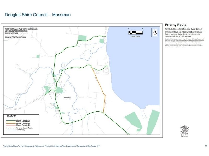
2. Mossman to Newell Beach
- Route: Commencing at the turnoff to Foxton Avenue in Mossman, this route travels down Mossman Daintree Road turning towards Newell Beach at the intersection with Newell Road, concluding at Marine Parade.
- Distance: 5.2 kms
- Category: Principal Route
- Priority: A
- Status: Commenced
3. Mossman to Cooya Beach
- Route: Commencing at the turnoff to Junction Road, this route travels down Bonnie Doon Road (across Junction Bridge), before looping back to the Captain Cook Highway (south of Mossman) via Cooya Beach. In Cooya Beach, there is an additional off-shoot down Melaleuca Drive to Bougainvillea Street.
- Distance: 4.7 kms
- Category: Principal Route
- Priority: A
- Status: Commenced
4. Mossman CBD to Mossman Gorge Community
- Route: This route starts at the intersection of Captain Cook Highway and Johnstone Road and finishes at the Mossman Gorge Community.
- Distance: 3.6 kms
- Category: Iconic Recreational
- Priority: A
- Status: Commenced
5. Shannonvale Road Loop
- Route: This route extends off the Captain Cook Highway onto Shannonvale Road, south of Mossman, before continuing along Ponzo Road to Mossman-Mount Molloy Road where is connects back up with the Captain Cook Highway.
- Category: Iconic Recreational
- Priority: Not identified in Action Plan for Douglas Local Government Area 2020
- Status: Not commenced
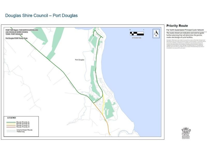
6. Captain Cook Highway to Port Douglas
- Route: This route extends off the Captain Cook Highway along Port Douglas Road, onto Macrossan Street before turning left and travelling along Wharf Street.
- Category: Principal Route
- Priority: A
- Status: Commenced
7. Mowbray River Road Loop
- Route: This route extends from the Captain Cook Highway along Mowbray River Road, taking in the Mowbray National Park and the famous Bump Track before looping back to the Captain Cook Highway along Tresize Road.
- Category: Iconic Recreational
- Priority: Not identified in Action Plan for Douglas Local Government Area 2020
- Status: Not commenced
Route Maps
Enquiries
For more information or if you have any questions, please contact Council on 07 4099 9444 or email enquiries@douglas.qld.gov.au


